Like the canyon

May 16, 2024

Recent EntriesHomeJoin Fast Running Blog Community!PredictorHealthy RecipesBryce's RacesFind BlogsMileage BoardTop Ten Excuses for Missing a RunTop Ten Training MistakesDiscussion ForumRace Reports Send A Private MessageWeek ViewMonth ViewYear View
JanFebMarAprMayJunJulAugSepOctNovDec
20092010201120122013201420152016
15% off for Fast Running Blog members at St. George Running Center!

Location:

Ogden,UT,

Member Since:

Nov 21, 2009

Gender:

Male

Goal Type:

Other

Running Accomplishments:

Finished my first 100 miler in '10, the Bear 100 in 26:05. 

55K 5:13

50 mile 7:47

Big Horn 100 Mile 24:54

 Squaw Peak 50:

2009: 13:48 (140th OA)

2010: 11:06 (26th OA)

2011: 10:01 (7th OA)


Short-Term Running Goals:

2012 schedule:

Red Hot 50K+  (5:23)

Buffalo Run 50 mile (7:47, 1st AG, 7th OA)

R2R2R

Squaw Peak 50 mile (11:40)

Big Horn 100 Mile (DNS)

Loco

Bear 100

Chimera 100

Zion Travers (Done)

Long-Term Running Goals:

God created skis and surfboards to keep the truly gifted from ruling the world.

I've finally let go of my preconceived notions of what it's supposed to feel like to run. - Geoff Roes


"If I had eight hours to chop down a tree; I'd spend six of them sharpening the axe." Abe Lincoln


Personal:


Favorite Blogs:

Click to donate
to Ukraine's Armed Forces
Miles:This week: 0.00 Month: 0.00 Year: 0.00

ZION TRAVERSE

50 miles, 10,000 vertical feet of climbing, 11:30

(lots of type o's hurrying sorry)

The short story is this is one I have wanted to do for a while.  The weather looked perfect for this weekend so on kind of whim I set it up and headed down to get it done. 

Zion Traverse is a point ot point run that traverses the entire National Park from east to west.   Being point to point means the start and finish are about 70 miles apart, making this a tough one to do solo.  I had everyhting arranged with a shuttle company (funny quote from girl on phone at shuttle Zion Adventure Co "You're going to do the entire Zion Traverse in a day?....who the hell am I talking too?") to pick me up at the finish in the morning and drop me at the start, but lucky for me a friend decided lastminute to come down and do some hiking, so he was able to shuttle me back to my car.  I'll describe the run in the picture captions below.

 I started at Lee's Pass in the Kolob section of the park.  The first 4-5 miles are all down hill meaning they should be fast and easy, but most of the trail looked like this, up a little hill down a little hill, cross a creek, repeat....like 20 times at least.  I tried hard to keep my feet dry as it was cold (28 degrees) and windy.  Had I had any idea what was coming I would have just splashed through every crossing. 

 A few miles in the trail bends left and follows Laverkin Creek.  I was a little worried about crossing this all morning and when I got close, but still out of site, I could hear a roar and I thought it was the wind blowing through the pines, wrong, it was a very swollen Laverkin Creek.  Crossing this took at least 20 minutes of walking up and down the bank trying to find a spot where I was relatively certain I wouldn't drown getting over it.  I settled on a jump across a dangerous section the was narrow, deep, and fast.  The jump was the running, hop two boulders and let fly type that I wasn't certain would carry me all the way to the steep bank on the other side.  I landed just short but only in knee deep water, grabbed at tree branch and hauled my self out.

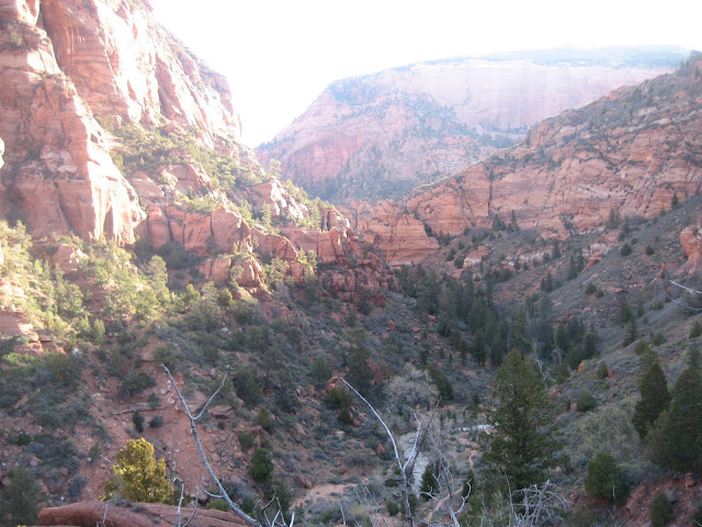
 Climbing up toward Hop Valley, looking back down on Laverkin Creek.  About 8 miles in.

 Looking down the misery that would be Hop Valley.  I knew this section would be pretty, but I also knew I would struggle through here.  The wide sand in this picture ontinues all the way down the valley and with the calf/ahilles thing I have had going on, I woudn't run through loose sand as it was too hard on my still healing body.  Lots of walking, lots of looking for frozen sand to run on.  One thing about this run is it is a sandbox in many sections.  Deep, deep very fine loose sand that is difficult to run through even healthy.  I would estimate 15-18 miles of deep sand in total.  Oh, and the water you can see in the pic, frozen, but only about 1/8 of an inch thick, so everytime I had to cross (often) it was breaking ice into freezing water, luckily only ankle deep or so. This section took much longer than planned. 

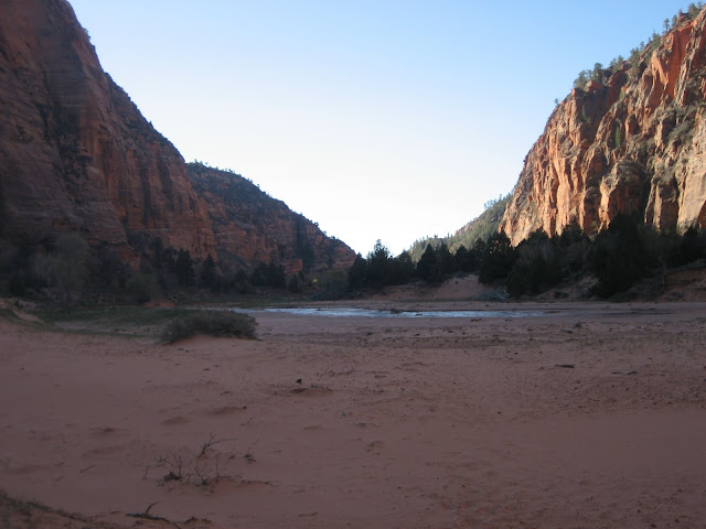
 Looking back toward Laverkin Creek from the end of Hop Valley.  Very pretty, but glad it was over.

 The next section is the connector trail from Hop Valley to the Wildcat trail.  It essentially paralells the the Kolob Terrace road.  A very enjoyable section, but tricky to follow in one spot.  After a creek crossing I ran in to  a group who had lost the trail.  I wasn't obvious to me either and since they had a GPS I followed them.  They were going left (toward the road) and I knew the trail went right, but heard mentality kicked in and I followed along.  I finally caught up to the guy with the GPS unit and he showed me the screen, he said "see the trail should be right here" well, I am not much of a GPS guy, but I could see that his "trail" was the road, but by then it was too late and we were practically on the highway.  I knew I could run up the road to get to Wildcat trail so that's what I did.  It added about a mile and a half to the total.  The pic is what I get for following the heard instead what I knew was the right direction. a mile and a half of uphill highway running, fun!

 Pretty meadow along Wildcat trail, which I should have renamed Wildcat Creek as 75-80% of it was flowing water and/or deep mud from all of the runoff.  Very pretty section, but tough, tough, tough!

 Awesome view into Wildcat Canyon. 

 Coming down the West Rim trail looking across to the East Rim and Observation Point.  At this point I still had a long drop to the canyon bottom and a long climb back out.  About mile 33-34 at this point.

 The trail down the west rim as it enters into the sandstone.  Not muddy!

 Welcome to Disneyland.  Strange to have been way out pretty much alone all day and come into the Angle's Landing section and throngs of hikers. 

 Looking down Zion Canyon toward the Grotto.  When I got to the Grotto I waited a while for the buddy to get there as he had met me coming down the west rim and I was a littel ahead of him.  From the Grotto the route goes up the main canyon 1.2 miles to the Weeoing rock, Observation Point shuttle stop.  As I waited, I dreaded the mile up canyon, running on the pavement and was tempted to get on a shuttle to the next stop.  I justified it in my head overand over that I was already 2 miles over what I was suposed to be from getting lost on the West Rim.  In the end I sucked it up and ran the mile or so, wasn't that bad. 

 Looking back down on Weeping Rock from part way back up the East Rim.  Tough climb at mile 40 plus.  Still passing lots of hikers at this point. 

 Pretty section along to East Rim trail.  Shortly after this, the trail splits, going left, and much more traveled to Observation Point, or right, very rugged, to the East Rim/Cable Mountain. 

Finally, nearing the top of the climb up the East Rim.  Looking back to the North West. About 5 miles left to go from here. Once I left the Observation Point trail, I was prety much alone for the last 8 miles or so.  Very pretty all the way to the end. 

Quick thoughts.  Body felt great all the way through.  No real deep fatigue, felt strong al lthe way to the end.  Didn't push much as I was trying to take it easy on my Achilles/calf. This is a tough route! Maybey it was just the conditions, lots of water/mud and sand, (bad combo for one's feet) but it felt rough! Much harder than a race like Squaw Peak and comparable to the Grand Canyon r2r2r I would say.  I ran totally unsupported and carried everything all the way through.  I wasn't confident on my ability to find the numerous springs along to way so I probably carried way too much water all the way through as well. 

   I feel good about my time.  Only about 25 minutes slower than my Squaw time last year, I didn't push my pace ever and this was much tougher, and I carried a big pack (well, for trail running anyway) all the way through.  I burned a fair amount of time at Laverkin Creek, gettng lost, and in Hop Valley trying to avoid the ice and sand. I feel good about where I am at fitness wise, just need to heal up a bit more so I have confidence to push it. Great weekend and glad  icould tick another one off the list, and probably put it back on the bottom as one to do again.


Comments
From jun on Mon, May 02, 2011 at 11:32:06 from 66.239.250.209

Really great report Bryce. I'm hoping to get down there in about 2 weeks. I have a couple of thoughts/questions:

Why did you choose to go west to east? Most people go east to west now-a-days as they say it feels easier. Your perspective would be good to consider for my trip.

Hop Valley = hell! I've hiked out of that thing after doing a first descent on the back side of Kolob down a wicked-cool slot canyon. I hate Hop Valley with a passion.

Other than finding the Connector Trail was it tough to stay on course? I think my biggest worry is making sure I stay on the trail.

What kind of food and how much water did you carry? I'm hoping to manage a lot by filtering, but I'm curious about nutrition.

From Aaron Kennard on Mon, May 02, 2011 at 11:33:25 from 98.245.117.176

WOW! Aaron: "What did you do this weekend Bryce?" Bryce: "Oh, just a little traverse across Zion, nothing too much."

You are nuts man! In a cool way. That scenery looks epic.

From Bryce on Mon, May 02, 2011 at 11:54:38 from 76.27.58.194

Thanks ands Aaron!

Jun, East to West would feel easier, but the other way around was easier to manage with the shuttle, and that's how I planned it so even with the ride that's how I did it. Water isn't a problem. Springs are obvious and numerous, look at www.citrusmilo.com/zionguide/recommend.cfm -

Has well marked maps of springs. Shouldn't even need a filter.

Food for me, running = gels lots of 'em. That's all I took. With a cooperative crew, or a lot of running around dropping caches, you could easily have support in several areas as I'm sure you know being a zion veteran. Should be much tamer trail in 2 weeks, snow was not an issue, but wet trail and mud were, really bad. If it dries out will be much quicker. Enjoy it!!

From Scott Wesemann on Mon, May 02, 2011 at 12:36:24 from 66.239.250.209

Wow! Great report and pics. I'm hoping to do this with Jun in a few weeks as well, so this is good to see. Hopefully it will dry out a little before then. Congrats on the run man.

From Bryce on Mon, May 02, 2011 at 15:47:37 from 174.23.80.229

Jun, oh, and as to staying on trail, no problem at all. Even the connector was easy to follow, I just got caught up following the group in front, if I had taken a second or two I'm sure I would have found the trail after the crossing.

From Oreo on Tue, May 03, 2011 at 12:32:02 from 206.81.136.61

Epic - my brother! Great run. You killed that trail. I think you are sharkin everyone with this talk about the calf/achilles... You're part Mtn Goat...

From Dorsimus on Tue, May 03, 2011 at 16:41:11 from 66.239.250.209

Wow. Fantastic report with amazing pics!! Nice job!!

From gdoc on Wed, May 04, 2011 at 01:17:30 from 98.202.195.25

Amazing adventure as usual for ManGoat! Totally impressive...not least of which is the superman over Laverkin Creek.

From Kelli on Wed, May 04, 2011 at 13:44:25 from 71.219.96.115

WOW, quite the adventure, alone and unsupported!!! I am glad you had enough water, better safe then sorry (you never know when you will get lost!!!) Thanks for sharing the details and the pictures!

NOW, fill me in on the achilles and calf stuff!!!!!!

From Bryce on Thu, May 05, 2011 at 10:16:47 from 76.27.58.194

Thanks all!

Kelli - Calf/Achilles...Question would be how long and how bad? only when running? and through the while run or just the first few minutes? Any soreness in the morning?

Basicly what I've gathered, and maybe its common knowledge, but mild soreness only while runnning and early in the run that goes away is generally no big deal, but something to keep an eye on. Beyond that, more pronounced/lingering pain that lasts through a run is somehting to pay attetnion to. I'd see a sports med doc at that point. A treatment callled ASTYM (usually done by a PT on refferal from a sports med doc) has cleared mine (and others) up pretty fast (my left Achilles last year, which is pretty much 100% now, and my right this year which was worse to begin with, but is getting to 85% I'd say). 2-3 times a week for a couple of weeks. Also, since most Achilles pain is the result of a tight calf, ART (Active Release Technique) in combo with the ASTYM has been pretty effective. ART loosens the calf, which is the cause of mine, and ASTYM helps the tendon heal. Really though, if it's even moderately bad, don't ignore it. I did on my right heel and it's taken forever to get back to right, still not all the way there. Oh, and one last thing...shoes, worn out? or have you changed brands or models lately? first question my PT asked? my answer, yes to both. Hope that helps a little, can't say enough about how helpful both ART and ASTYM have been.

From Kelli on Thu, May 05, 2011 at 13:55:46 from 71.219.96.115

The pain is the worst in the morning when I get up. It loosens up pretty quickly once I get moving. It hurts just in the beginning of a run OR if I do too many hills or too much speed. It hurts a few hours after the run is over. Yoga really bothered it the other night, so stretching must not be good!

Let's see, it started after the 50 miler in March. NO new shoes, aside from the fact the I bought Cascadias for the race (wore them for about 2 weeks before), but I only where them here and there now. None of my shoes are worn out, I rotate between 3 pairs (4 counting the Cascadias).

I may just call the doctor, I would like this to go away! THANKS!

Add Your Comment.
  • Keep it family-safe. No vulgar or profane language. To discourage anonymous comments of cowardly nature, your IP address will be logged and posted next to your comment.
  • Do not respond to another person's comment out of context. If he made the original comment on another page/blog entry, go to that entry and respond there.
  • If all you want to do is contact the blogger and your comment is not connected with this entry and has no relevance to others, send a private message instead.
Only registered users with public blogs are allowed to post comments. Log in with your username and password or create an account and set up a blog.
Debt Reduction Calculator
Featured Announcements
Lone Faithfuls
(need a comment):
Recent Comments: