Well, where to start with this one.... Nutty week, pretty much worked 40 hours betweeen Monday and Wednesday. With so much work, there was very little running early in the week, no running Thursday or Friday as I was out of town for work. This little trip pretty much invloved a circumnavigation of the state of Wyoming with a stop in Rapid City, SD and a quick drive by of Mt. Rushmore.
I took my running gear, figuring I would try to get a run in somewhere along the way. I threw in my Teton's map and Windrivers maps as well knowing I would be in the area. A little web search and it was pretty clear the Tetons's were still too snowed in for much running. Option two was to head into the Wind Rivers on the Glacier trail to scout it out as it would be part of a full traverse of the range I would like to do at some point.
Looking at the map and reading the guide, the route had the potential to be a 48 mile out and back. Feeling how I was (no sleep, not eating well, and still have a respiratory thing going on) I figured I'd go in for 5 hours and see where it got me, turn around and head back out.
Here is the run in pictures.

Early in the run, first mile couple of miles. Much drier on the East side of the range. Got a bit of a late start this morning as I was trying to catch up on a little sleep.
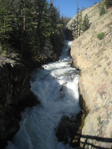
Right off the bat I came to a sturdy (thankfully) bridge across this roaring little gorge.

Wild flowers were out in force in the mid-elevations.

Trail climbed almost 4000 ft in the first few miles up to above treeline and through this a pass at 11,000 ft and through this huge open meadow filled with flowers. Looking ahead to where I am going. The Dinwoody creek drainage is the far canyon visable in the distance. The Glacier Trail goes up that drainage to the foot of the Dinwoody Glacier below Gannet Peak, The highest point in Wyoming.

Double Lake. About 2 miles and 800 feet below the pass from the previous photoe. Pretty spot and the first snow I encountered was here, though very little on the whole route. Wish I had time to explore above this lake, upper Phillips and Golden lake look like they would be awesome places. If I were into fishing I would go back to Golden Lake, as a friend of mine caught some huge Golden trout (colored like a Gold Fish) up there last year.

2-3 miles past the lake pictured above and after some really rough trail and a fair bit of climbing I came to a shallow pass above Honeymoon lake. The trail descened here past this lake and all the way down to Dinwoody creek. Getting hot and the mosquitoes are getting very thick! Probably 10 miles in or so at this point. Saw a few parties on there way out just before the 11,000 foot pass, but haven't seen a soul since. Starting to feel a bit trashed, low energy and my Anterior Tibial tendon on right foot/ankle was getting really tight for some reason. Probably the 1100 miles I had driven in the 24 hours before the run.

Typical trail on this route. Either rocky like this or muddy/swampy and rutted out.

Dinwoody "Creek", a couple of miles and steep, rocky descent from Honeymoon Lake pictured above. Water was a cool blue/grey color from the Glacier melt. Very pretty, but was hoping it wouldn't require crossing. Trail continues up river from here, climbing and descending through many small valley along the way.

Side creek the trail went past. Crazy amount of water through a really narrow gorge. Wouldn't want to end up in there. About 14 miles in, still haven't seen a soul. Feeling pretty crumby still, haven't hit my 5 hour turn around time yet, but thinking I might call it a day and turn around, but I really want to get to the point the Gannet Peak is visiable up the valley. Hoping it's not much further.

Mellower stretch of the Dinwoody Creek. The water color is more apparent in this one. Really pretty. Getting really hot!

Broad marshy valley about a mile up canyon from the last pic. You can see the trail along the right side of the river. I continues up stream on the right side of the broad green marsh and into the pines beyond. Trail was pretty swampy through this section. LOTS of mosquitos! and very hot. I think I picked the calmerst day of the year to be out here. Typically there is a breeze in these canyons and especially on the high passes. A little breeze does two thinngs, makes it not as hot obviously, but even more important it keeps the bugs down. Not today, hardly a lick of a breeze all day. Hard to put into words the number of mosquitos, they were not terriable if I was moving, but stop, even to tkae a picture like this, and 10-15 would land on my arms alone. Bug spray was almost useless.

This was taken beyond the meadow and valley pictured in the last photo. looking back down canyon to a bridge that crossed Dinwoody Creek at the Ink Wells trail junction. Very pretty spot, but I'll say it again, bugs, hot! About 4 hours in and 16 miles or so. Moving really slow trying to baby my foot which isn't terriable, but don't want it to get worse. The roughness of the trail and temps made it hard to move a whole lot faster anyway. Really hoping Gannet comes into view soon! Ready to turn around and head back to the car. Havent seen any people yet. Starting to feel a bit isolated out here. Figuring if I was going to see a bear it would be in this section. Great bear terrain and I was starting to see alot of bear crap around.

Finally! Came around a corner a mile or so above the bridge and there it was! Beautiful view of the east side of Gannet. I have approached this peak from the West side of the range before, but it looks very differernt from this view! Awesome. Just over 5 hours in, probably 17.5 miles. Now I just have turn around a do it all over again back to the car. One thing I didn't pay enough attention to when I set out on this adventure was the climb back out of the river valley to the pass/meadow before dropping back down to the car. Uggggh! like 3000-3500 ft with all the ups and down in between.. One more time, bugs, hot!
Really feeling bonky and beat at this point with a long way to go to get back to civilization. That's one thing about these middle of no where adventure runs, there's no DNF. No matter how bad I felt, there is not other way out but to walk/run. I hadn't even seen another person for many miles and hours.
I am sure most of the physical low was a result of the days leading up to this run. See stats below for the reason.
The return trip was pretty much a slog/suffer fest. Couldn't get a good run going so it mostly a walk even on the downhills. Some of the big climbs required a mid climb "aid station" stop that involved sitting down until the bugs got too bad and drinking and "eating" some gel.
Stats:
Miles driven: 1700
Miles run: About 35, vert 8000 or so.
Pace: Slow
Meals eaten that weren't out of a cooler, gas station or grocery bag: 0
Total hours of sleep from Wednesday night to Saturday morning: 11
| 